Invasive Plants in View
Monitoring in the Karawanken UNESCO Global Geopark
Together we can limit the spread of invasive species and protect the biodiversity of our mountain regions!
Project description
Our Citizen Science project is dedicated to the spread of Invasive Alien Species (IAS) in the Geopark Karawanken. Invasive species are plants or animals that are mostly introduced by human activity into regions where they do not originally occur, for example through intercontinental trade. While most introduced species are dependent on human support to survive, there is a minority that can adapt to the new environment and survive independently. Some of these species develop large populations very quickly and pose a significant threat to native ecosystems.
You can find a brief overview of our project in this video:
The problem
Invasive alien plants can spread rapidly because they produce large quantities of seeds, grow quickly and have few natural enemies in their new environment. This enables them to colonize new areas quickly and displace native species. They can also pose a direct threat to humans, for example through negative impacts on infrastructure or human health.
Mountain regions are currently less affected by invasive plants, but the risk is increasing due to climate change and human land use. The species are often introduced at lower altitudes and spread along corridors such as roads, hiking trails and watercourses to higher altitudes. Seeds and spores can stick to tires, shoes and tools (such as tractors) and spread in this way. Intentionally introduced material, such as for road construction, or planting material, such as seed mixtures for roadsides or ski slopes, also contribute to their spread.
With our project, the Geopark Karawanken aims to create a basis for planning targeted measures to limit the spread of invasive plants.
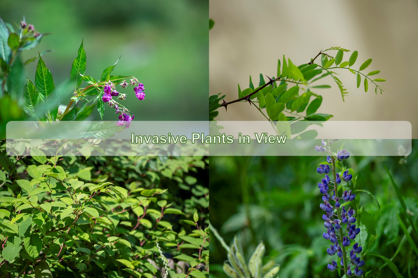
Examples of invasive plants and their characteristics:
-
 Canadian goldenrod (Solidago canadensis) CC-BY 2.0 Andreas Rockenstein (https://creativecommons.org/licenses/by/2.0/at/) Canadian goldenrod (Solidago canadensis) CC-BY 2.0 Andreas Rockenstein (https://creativecommons.org/licenses/by/2.0/at/)
 - Giant hogweed (Heracleum mantegazzianum) CC BY-SA 4.0 Dietmar Rabich (https://creativecommons.org/licenses/by-sa/4.0) Giant hogweed (Heracleum mantegazzianum) CC BY-SA 4.0 Dietmar Rabich (https://creativecommons.org/licenses/by-sa/4.0)
- Himalayan balsam (Impatiens glandulifera) © Urosh Grabner Himalayan balsam (Impatiens glandulifera) © Urosh Grabner
- Japanese knotweed (Fallopia japonica) © Urosh Grabner Japanese knotweed (Fallopia japonica) © Urosh Grabner


https://www.citizen-science.at/en/projects/invasive-plants-in-view#sigProId75c9df7eb2
What can I do to support the project?
You can share locations of invasive plants with us via the iNaturalist platform and thus make a valuable contribution to protecting the native flora and fauna in the Karawanken Geopark area.
To help you get started, here is a step-by-step guide for Citizen Scientists:
Part I: What is iNaturalist and how can I use the platform (GER)
For Geopark schools and hiking guides:
Raise awareness of invasive plants in the Karawanken-Karavanke UNESCO Global Geopark and support us in documenting affected sites: During a hike or as part of a school excursion, you can document invasive plants in iNaturalist together with your group and educate participants about their problems and impacts on native ecosystems.
You can of course use all available documents (short video and step-by-step instructions) for your activity. If you need further support for the implementation, please contact us (This email address is being protected from spambots. You need JavaScript enabled to view it.).
Do you want to take action and stop the spread of invasive plant species?
If you want to do more, you can help us control the spread of plants:
Remove neophytes in your neighborhood
If you live nearby, you can clear an area in your neighborhood of neophytes in consultation with the landowner. There are different methods of removal depending on the plant in question. Balsam, for example, can be easily pulled out along with its roots. Remove the plants BEFORE the seeds ripen on a dry day. Canadian goldenrod can be pulled out by hand or with a spade when the soil is moist. Large populations can be reduced by regular mowing BEFORE the flowering period. Plant parts can be composted on site, roots, flowers or seeds can be transported away in bags and disposed of in residual waste to prevent the plant from spreading further.
Instructions for the removal of various invasive plants can be found in the practical guide Neophytes from the Swiss Agency for Environment & Communication.
Organize your own joint action to remove neophytes in the Karawanken Geopark
You can also organize a joint action to control the spread of neophytes in the Geopark - for example with your school class or as a hiking group. Clarify the action with the landowner of the area beforehand. The Geopark Karawanken team will support you with the planning.
We would be delighted if you kept us informed about your activities at This email address is being protected from spambots. You need JavaScript enabled to view it.
Thank you for your support and your valuable contribution!
ATTENTION Giant hogweed!!!
What should I do if I discover the giant hogweed in the Karawanken Geopark?
- Keep enough distance from the plant.
- Avoid skin contact and wash the affected areas immediately.
- Document the plant and its location (on iNaturalist).
- Inform other hikers and mark the location.
- Notify the municipality and/or the Geopark Karawanken team (This email address is being protected from spambots. You need JavaScript enabled to view it.)
- Monitor your skin for reactions and seek medical help if necessary.
- Please DO NOT remove the giant hogweed yourself without protective equipment!!!
Further details to the project
Project Area
The Karawanken UNESCO Global Geopark covers an area of 1,067 km² and includes five Slovenian and nine Austrian municipalities. This cross-border area is a unique natural and cultural experience region characterized by its outstanding geological heritage. The aim of the Geopark is to preserve the geological and natural resources as well as the cultural heritage of its members. By raising awareness, providing information, and education about the Geopark and its network at European and global levels, it contributes to strengthening its position as an important geopark. The Geopark also promotes economic use through sustainable tourism and supports cross-border cooperation for the sustainable development of the region.
Further information about the Karawanken Geopark can be found on the Geopark homepage and our social media channels (@visitgeoparkkarawanken).
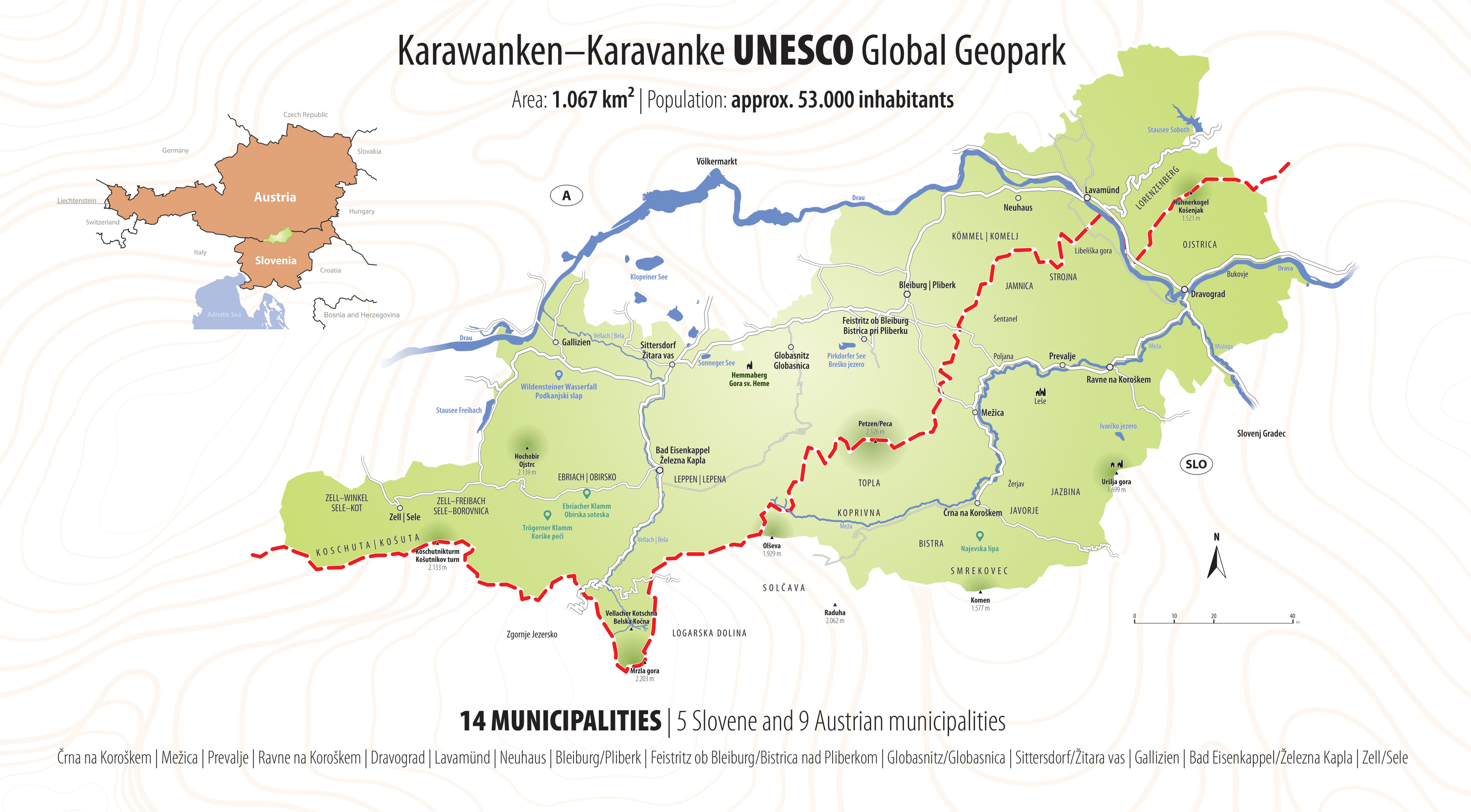
Image 3: Overview map Karawanken UNESCO Global Geopark © Urosh Grabner
Project Goals
- Monitoring and Early Detection: Establishing a network to monitor invasive species in the Karawanken UNESCO Global Geopark in order to detect their spread at an early stage.
- Awareness-Raising and Education: Informing and involving the population about the importance and impact of invasive alien species and the influence of climate change and human activities on their spread.
- Data Collection and Analysis: Collecting and analyzing data on the occurrence and spread of invasive species by citizen scientists.
- Management and Control: Developing an action plan to control and contain invasive species in order to protect native ecosystems.
Methodology
- Participation: Involving the population as citizen scientists who collect data on the occurrence and spread of invasive species.
- Training and Workshops: Providing online educational materials and workshops to equip participants with the necessary knowledge and skills to identify and report invasive species.
- Online Green Academy
- Workshops
- Data Platform: Using the iNaturalist platform to record the locations of plant species. The collected data is validated there and then analyzed and published by the Carinthia University of Applied Sciences (UNESCO Chair for Sustainable Management of Protected Areas).
Expected Results:
- Improved Data Basis: Basic data collection on the occurrence and spread of invasive species in the Karawanken Geopark.
- Increased Awareness: Better-informed and engaged population actively contributing to monitoring and protecting native ecosystems.
- Effective Management Strategies: Action plan to control and contain invasive species in hard-to-reach areas.
Data Protection Information
No participant data is analyzed in this project. By joining, participants agree to iNaturalist's terms of use. Users control what data is visible to others when creating iNaturalist data, and settings can be managed in account details on the platform.
Project Details and Contact
This project is co-funded by the INTERREG Central Europe project HUMANITA - Human-Nature Interactions and Impacts of Tourism Activities on Protected Areas, supported by the Interreg CENTRAL EUROPE Program 2021-2027 with co-financing from the European Regional Development Fund (ERDF). The project's total budget is EUR 2,396,346.70, with EUR 1,917,077.36 funded by ERDF.
If you have any questions or require further information, please do not hesitate to contact us:
FH Kärnten: Lilia Schmalzl (This email address is being protected from spambots. You need JavaScript enabled to view it.)
Karawanken UNESCO Global Geopark: Urosh Grabner (This email address is being protected from spambots. You need JavaScript enabled to view it.)
This project fulfils version 1.1 of the quality criteria for citizen science projects on Österreich forscht.
- land use
- plants