COwLEARNING
Breaking the blame game:
COwLEARNING for sustainable beef and dairy supply
Our society faces grand challenges, such as mitigating climate change and adapting to its consequences, ensuring a healthy diet and maintaining cultural landscapes with high biodiversity. A sustainable agri-food industry addresses these challenges.
In Austria, with its high share of meadows and pastures, cattle husbandry is particularly important. Several aspects of dairy and beef supply are perceived as unsustainable. This is for instance its impact on climate change because during their digestion cattle release the climate-damaging greenhouse gas methane. Moreover, both animals and humans often face welfare problems because of difficult living and working conditions on farms and abattoirs. Many animals are kept in small spaces for the production of cheap products in a competitive market. Cattle are then prone to illness and their treatment with antibiotics may result in antibiotic resistance. In addition, our high consumption of meat causes health risks.
These and other problems in our beef and dairy supply are broadly discussed but many questions remain unanswered:
- What has driven past changes in dairy and beef supply and why have sustainability innovations (not) been implemented?
- How do alternative dairy/beef chains compare in terms of animal and human welfare, the environment, socio-economic characteristics, and potential for growth?
- What are broadly acceptable and feasible changes for the future?
The project COwLEARNING combines scientific knowledge from the universities with the knowledge of practitioners in farming, processing, retail, gastronomy and consumption*. Together, we search for possible ways of change and thereby consider different innovative practices. This may include, for instance, pasture-based feeding, cow-calf contact systems (the calf stays with the cow for longer time after birth), mobile abattoirs, cow-sharing (animals are slaughtered only when all their parts are sold), milk and beef substitutes.
With a farm-to-fork assessment, we compare these innovations from the farmer to the consumer. Together with practitioners, we develop scenarios, this means pictures of the future showing alternative developments. In addition, we develop serious games to convey the topic in a playful way. With these approaches we want to stimulate learning and provide spaces to experiment with more sustainable beef and dairy supply.
*Participation is limited to these stakeholder groups and therefore closed.
Citizen Science Seminar
In January 2024, poject coordinator Marianne Penker held a lecture about the project (in German) as part of the lecture series "Citizen Science Seminar" at BOKU University.
Picture gallery
-
 Common Vision © Jana Wiese Common Vision © Jana Wiese
 - Projectstart © FWF-LuizaPuiu Projectstart © FWF-LuizaPuiu
- Transdisciplinary Team © COwLEARNING Transdisciplinary Team © COwLEARNING


https://www.citizen-science.at/en/conference/tag/land%20use?start=20#sigProIda65ba1cecd
This project fulfils version 1.1 of the quality criteria for citizen science projects on Österreich forscht.

Werkstatt Neu Leopoldau
The research project Werkstatt Neu Leopoldau is focused on the settlement process as a workshop situation for social innovations in housing and urban development, with the aim of fostering sustainable development and creating good neighbourhoods.
As an applied research project, "Werkstatt Neu Leopoldau" (Co-creation Neu Leopoldau) accompanies the settlement process of the IBA quarter in Vienna's 21st district. The phase of residents' and users' arrival in the neighbourhood is explored, which is conceived as a potential for social sustainability in Viennese housing. Using proven and new practices as a starting point, settlement processes are viewed as learning and education processes. Furthermore, it entails socially integrative potentials that should be shaped and further developed in a collaborative and co-creative setting to think about future ways of living in the neighbourhood.
In a first step, relevant topics and questions will be developed in a co-creative process based on the experiences of the actors involved. Special attention is paid to established and future social innovations in urban development (e.g. social innovations such as social support in the settlement process, community spaces, and sharing of further resources, etc.). In a synthesis step, a selection and focus on key topics are undertaken, which are then elaborated in more depth with the target groups in collaborative workshops. The aim of the innovation project is to develop transformational knowledge in a spatial context to enable and strengthen learning and educational processes at the individual and institutional level.
The project was carried out from November 2022 until September 2023, involving residents, tenants, property management companies, and experts who are accompanying the settlement process. Werkstatt Neu Leopoldau is supported by the IBA_Wien 2022 of the City of Vienna, MA 50, and a series of further cooperation partners.
Transdisciplinary research team
- future.lab Research Center TU Vienna: Christian Peer (project leader), Magdalena Augustin, Tamara Bauer, Ruth Höpler
- Citizen scientists: residents of Neu Leopoldau
- Practice partners: GB* district management Neu Leopoldau, property management and further experts, who professionally accompany the settlement process
Podcast episode
In September 2022, project leader Christian Peer was a guest on the Österreich forscht podcast "Wissen macht Leute" - if you're interested to learn more about the project, you can listen to the episode here (in German). In addition, Maria Schönswetter, a dedicated Citizen Scientist in the project, gave interesting insights into the project in March 2023 - tune in!
Results
You can download the final report directly from IBA_Vienna 2022 website or from the future.lab website!
Read more about the findings and results in our blog entry!
![]()
This project fulfilled version 1.1 of the quality criteria for citizen science projects on Österreich forscht.

Looking for Cowslips
In spring, scientists invite everybody around Europe to take part in the biggest cowslip observation campaign “Looking for Cowslips”. The aim of the project is to examine the patterns of flower morphological traits (i. e. heterostyly) in cowslip populations all across Europe using a citizen science approach. The citizen science project “Looking for Cowslips” was carried out already in 2019 and 2020 in Estonia and Latvia. Within the frames of this campaign, we obtained heterostyly data from > 150 000 cowslip individuals in each year of 2019 and 2020 in Estonia (and Latvia). Since 2021 we are also asking enthusiastic citizen scientists across the EU to participate and contribute, with great success. Data originating from the campaign provides unprecedented insight into the patterns of heterostyly following the loss of semi-natural grasslands.
Participants are expected to observe the patterns of heterostyly in cowslips. The cowslip (Primula veris) is a heterostylous plant – it means that the plant can have one of the two types of flowers. These different types of flowers are called S-morphs (short-styled) and L-morphs (long-styled). In short-styled cowslips (S-morphs), five anthers are visible in the flower when looking from above, and in individuals with L-type flowers, a green dot in the middle of the flower (the stigma) is visible. Normally in cowslip populations, the frequency of these different types of individuals is more or less equal. Imbalance reduces a plants’ opportunities to find a suitable mate for reproduction, which impedes pollination and the exchange of genetic material. This, in turn, reduces a plants’ vitality. The cowslip’s regular habitats – traditionally managed grasslands – have become increasingly rare in the contemporary landscape. The disappearance of grasslands causes decline in plant populations depending on grassland habitats. A massive decline in cowslip populations can cause substantial imbalances in the frequency of L- and S-morphs to the extent that one of those types completely disappears from the habitat. That is precisely the kind of a possible shift in the balance between the L- and S-morphs caused by changes in the landscape that we want to study – with your help. An observation takes about 30 minutes. When possible, one should observe the flowers of 100 cowslip individuals. Look at the flower and report whether you see five anthers (S-morph) or one stigma (L-morph). Find the time, breathe some fresh air, and help scientists with their work!

For more information, check out our webpage www.cowslip.science.
To find out more about the interesting findings from the first year of the campaign, you can read the article at: https://besjournals.onlinelibrary.wiley.com/doi/full/10.1111/1365-2745.13488.
You can contact us at This email address is being protected from spambots. You need JavaScript enabled to view it. for further questions.
This project fulfils version 1.1 of the quality criteria for citizen science projects on Österreich forscht.

FotoQuest Go
“Explore the European landscape and help science to protect the climate and the environment!”
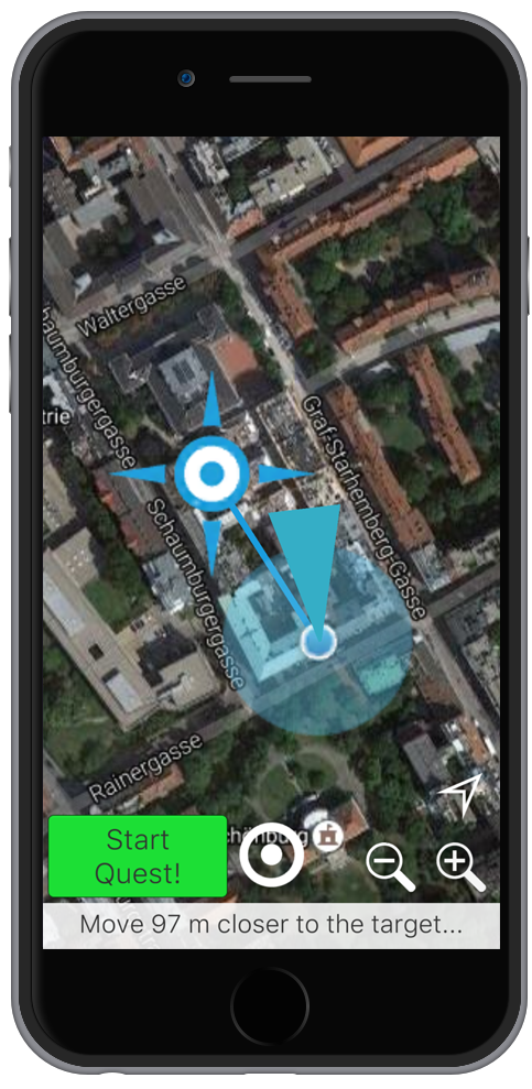
Do you like to be out in the fresh air? Would you like to make a concrete contribution to protect the environment and the climate and earn something in addition? With the FotoQuestGo app, you can use your free time to help science improve important data sets for research into landscape changes in Europe. The app works very simply: with the help of your smartphone's GPS, it navigates you to the place where we lack landscape data and then helps you to save and upload the necessary photos and information.

Why FotoQuestGo?
Every day in Europe, large amounts of land are converted into business, residential, leisure and traffic areas. Fertile soils, biodiversity and natural CO2 storage must give way to asphalt and concrete. In addition, the increasing surface sealing increases the risk of flooding drastically.
In order to better track and understand changes in land areas and their effects on the environment, scientists have so far lacked reliable, detailed and complete data on current land use.
With the FotoQuestGo app you can become a scientist in your free time and protect nature! With every place you explore, you make the data sets a little more accurate. And you collect valuable points for our prize draw. Are you ready for this challenge?
This is how it works:
- Download the app for free on your GPS-enabled smartphone.
- Register a FotoQuest account with your email address.
- Select a destination and use the app to navigate there.
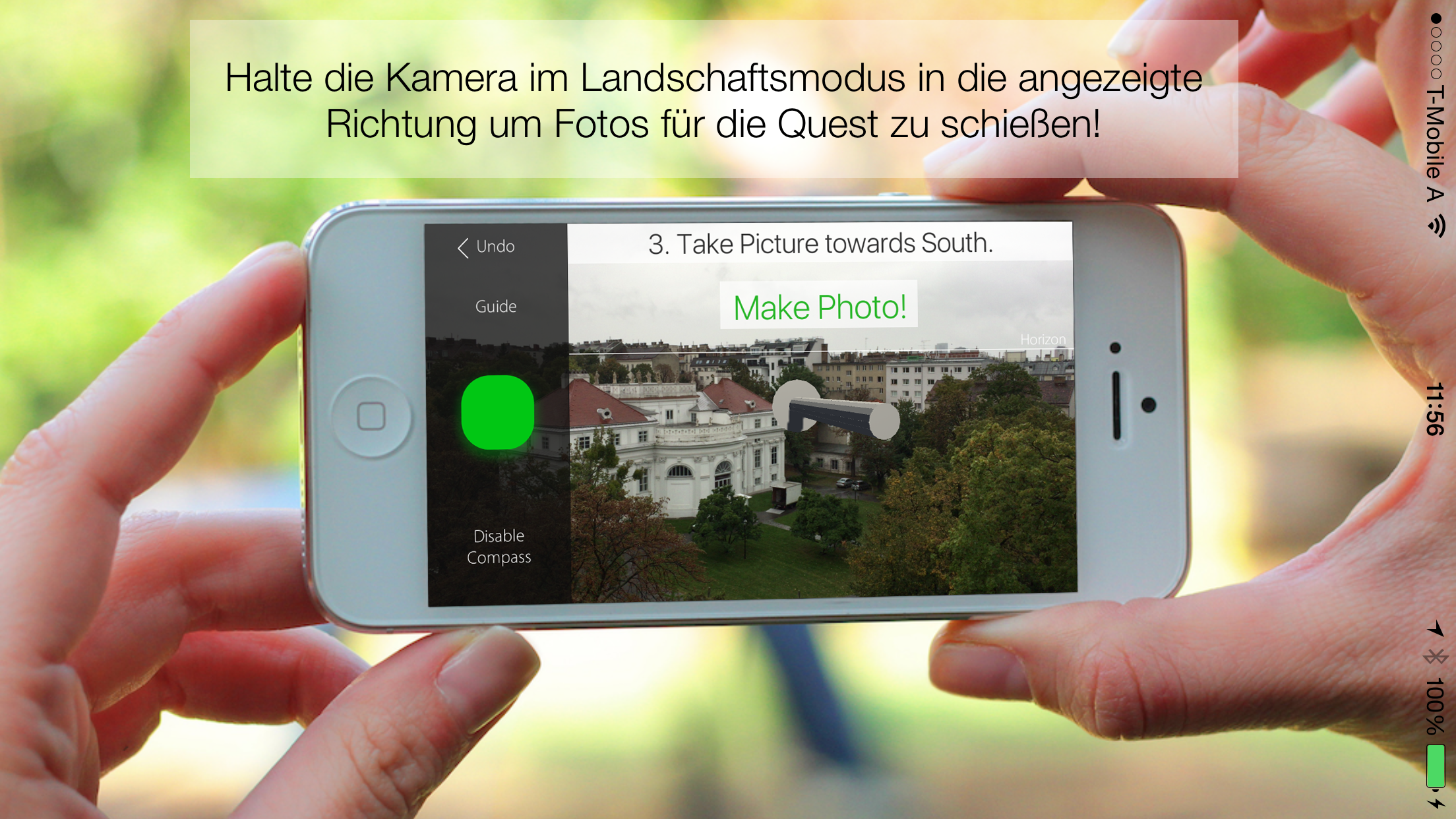
- At the destination, the app will help you take the photos you need:
- If the destination is difficult or impossible to reach (e.g. is on private land): A photo in the direction of the destination.
- One photo in each direction and on the ground. - Answer a few questions and, if possible, take one last, more detailed photo so that the scientists can understand exactly what the local vegetation looks like. For example, it is about finding out whether there is forest or arable land in the place you have explored and which trees or crops can be seen.
- Your photos and pictures will be uploaded automatically. If the connection is bad, you can also save it for later upload.
Tasks on the scientific side (project management):
The tasks depend on the respective campaign. The land use classes are determined by the local citizen scientists. The classes are closely based on the LUCAS (Land Use / Cover Area frame Survey) protocol. For use in the app, the parts of the LUCAS protocol that are essential for scientific processing are prepared in a form that is understandable and unambiguous for citizen scientists. Furthermore, quality assurance mechanisms were developed and applied to ensure the quality of the contributions on the one hand and to give feedback to the citizen scientists on the other hand in order to maintain and increase the quality of the contributions over the course of the campaign.
Tasks of the citizen scientists:
The data are recorded on site. The participants are in nature and can enjoy the environment. Citizen scientists are required to identify changes in land cover and to collect information on land cover at randomly distributed points. This concerns the type of land cover up to the level of e.g. the species of crops grown. Furthermore, the land use is roughly documented, as is the variability of the land cover in the vicinity of the points. This allows an assessment of which classifications can ultimately be used to validate land cover data sets from remote sensing.
This project fulfilled version 1.1 of the quality criteria for citizen science projects on Österreich forscht.

GEO Wiki
On Geo-Wiki.org you can participate in global environmental monitoring and help to observe and document the earth and what happens on it on a large scale. Whether it is deforestation, the varying size of fields in agriculture or the fast and precise evaluation of hurricane damage - your contribution is important to evaluate satellite images or to check the automatic evaluation of satellite images and existing maps of land use. In this way, you help scientists to create reliable information and accurate maps of the state and changes on our planet. How can this be done? Quite simple! You can take part in campaigns and games and contribute on a desktop computer as well as on mobile devices. The resulting data is open, free and can be used by everyone without restriction.
Video
This project fulfilled version 1.1 of the quality criteria for citizen science projects on Österreich forscht.

CrowdWater
CrowdWater is a hydrological citizen science project of the University of Zurich. CrowdWater uses an app to collect data about water. No prior knowledge is required to participate.
What is the project about?
CrowdWater stands for independent and reliable data collection by anyone with an interest in water. The observations collected with the CrowdWater app can complement existing measurements and be used for hydrological modeling. The method is being developed in Zurich and will also be used in remote areas and regions with low data availability.
How can interested citizen participate?
With the CrowdWater app for Android and iOS, participants can collect data on water levels (with physical and virtual staff gauges), soil moisture, the condition of temporary streams, plastic pollution and water body type independently and without measuring devices. New observation stations can be created anywhere in the world or additional observations can be added to an existing station.
In the CrowdWater online game, the data quality of the uploads in the category "virtual staff gauge" is checked and if needed improved by contributing citizen scientists.
What happens with the data?
The data are published anonymously on our homepage and can be used for free for own projects. In the research project, the data is used for hydrological modeling so that its potential can be investigated. Two PhDs have already been completed in the CrowdWater project, and two more PhDs are currently ongoing. Currently, the focus is on temporary streams and water quality observations. The publications that have come out of the project so far can be found here. What the current research team is working on can be read here.
Interactive map:
Citizen Science Seminar
In 2022, poject coordinator Jan Seibert held a lecture about Crowdwater as part of the lecture series "Citizen Science Seminar" at the University of Natural Resources and Life Sciences Vienna (BOKU): "What we can all observe - Experiences from the CrowdWater Project" (in German). Here, you can watch the video recording of the lecture on our YouTube-channel:
![]()
This project fulfils version 1.1 of the quality criteria for citizen science projects on Österreich forscht.

Wild Neighbours
Are swallows nesting at your house or in your stable? Have you seen a badger in the middle of town? Or do you regularly observe a kestrel in your garden? We are interested in your observations in rural settlement areas!

Homegrown
“Homegrown - There is nothing like a homegarden”
Project description
With their variety of plant species and the experience of the gardeners, rural home gardens constitute an integral component of the cultivated landscape in the Lienz district, East Tyrol. Together with pupils of the BG/BRG Lienz school (and biology, math/physics and English teachers), scientists are investigating rural home gardens, including stocks of plant species and the use of plants. These results will be compared with those taken 20 years ago from the same gardens and will help to identify changes in gardens and their cultivation. These diachronic perspectives allow a precise and empirically established overview of changes in rural home gardens in the countryside of an industrial and services-focused state, in the context of demographic and economic changes and the search for a new identity.
To gain a better understanding of the local perception of the significance of rural home gardens, observations from gardeners and their neighbours concerning ecosystem services in gardens and their significance will also be recorded.
The project will also investigate cultivation techniques that adapt to extreme weather or ensure sustainable growth. It will also find out why people grow gardens and which values and approaches guide their behaviour or actions in gardens.
As part of an additional citizen science module, the local population in East Tyrol and Oberen Drautal will be combined. The module appeals to gardeners who are interested in taking surveys in their gardens, according to methodological direction and by monitoring their gardens, so as to demonstrate the material and immaterial ecosystem services in gardens. These gardeners and the cooperating young people will be trained in simple quantitative and qualitative survey methods for this purpose. This will take into account the opportunities that depend on the education and experience of each individual participant.
The starting point for developing analogue survey tools for the researching gardeners is a universal T-card office planner (49 x 47.3 cm, 7 panels, light grey) with 20 slots and 7 columns. The card slot system provides a weekday structure (Monday to Sunday), an hourly structure (6 a.m. to 10 p.m.) and six variables for recording ecosystem services.
On the universal T-card planner, the gardeners use the provided weekday and time scales with differently coloured slots to record the following specific information in writing about the individual ecosystem services during the recording period:
- Provisioning services, such as the yield of vegetables and fruits from the home garden (name of the person harvesting, time and duration, name of the harvested fruits and vegetables, the amount harvested and its respective use).
- Regulating services, such as birds, insects or pests in the home garden (name of the observing person, time and duration, name and number of birds, insects or pests observed).
- Cultural services, such as cultivation techniques in the home garden (name of the person cultivating, time and duration, tools used, etc.) or activities in the home garden when used as a place for relaxation and leisure.
The time spent in the garden will be recorded with a simple stopwatch. Some plant materials will be weighed out with simple, easily available kitchen scales. The card slots will be placed somewhere protected from weather or positioned where they are in the gardener’s view. This location will be decided on site with the gardener.
The duration of collections using the card slot system will be calculated at at least a week and will then be passed on to another gardener. Seven card slot systems will be prepared. The recordings ran from 1 August to 31 August 2018.
Through the participation of citizen scientists, a continuous observation and record of local perception (emic viewpoint) of the ecosystem services of home gardens is guaranteed. The methods were proposed by a gardener from the region being researched and were discussed/considered together with other gardeners from the area. The citizen scientists were actively involved in data acquisition and collection, data analysis and interpretation and the publication of results in the project report, scientific journals and conferences and in local media (dolomitenstadt.at). The collected data was continuously documented and stored by scientific guardians. Interim and final results were returned to the participating gardeners as part of the “give back” culture in the citizen science final event (“Gartenfest”).
Project collaborators
Heidemarie Pirker
Brigitte Vogl-Lukasser
Partners
BG/BRG Lienz (Renate Hölzl, Arno Oberegger, Hansjörg Schönfelder and the pupils of class 6b (from academic year 2018/2019: 7b).
Marie-Luise Wohlmuth (workshops on soil biology)
Ramona Walder (photography)
Peter Werlberger (video)
Gerhard Pirkner (dolomitenstadt.at)
Germain Weber & Team (Faculty of Psychology, University of Vienna)
Christian Ragger (REVITAL - Integrative Naturraumplanung GmbH)
![]()
Image gallery
(Click on an image to enlarge)


https://www.citizen-science.at/en/conference/tag/land%20use?start=20#sigProId537f10b2da
This project fulfilled version 1.1 of the quality criteria for citizen science projects on Österreich forscht.

Tea Bag Index
Can tea help us understand climate change? Yes, but we need your help! We would like you to become our research partner and take part in one of the largest experiments on soil decomposition processes at the moment!

Citree
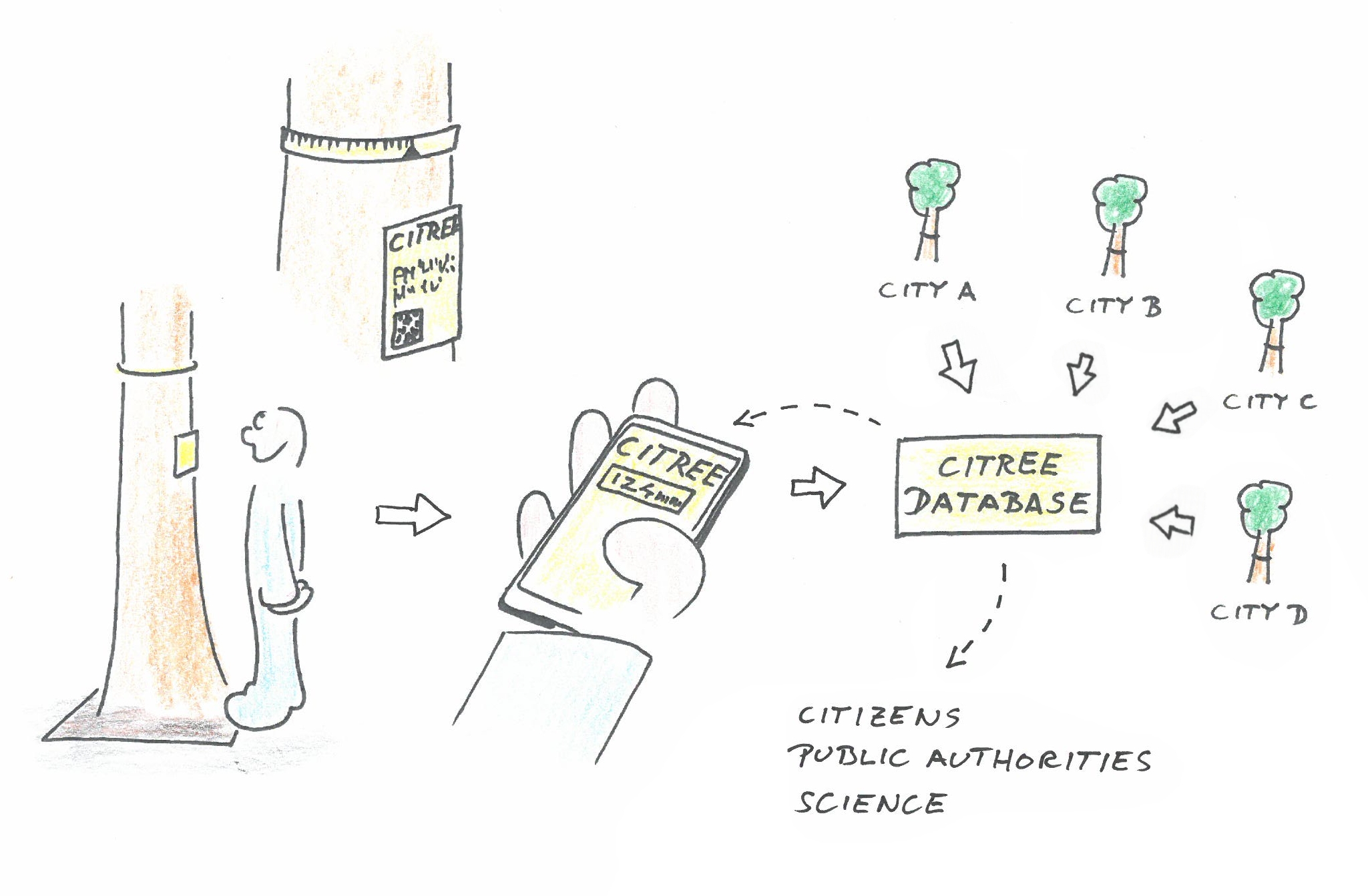
With the Citizen Science Project "CITREE" a crowdsourcing instrument for monitoring the growth of urban trees, will be developed and used. It builds on the "Sparkling Science" project "Woody Woodpecker", which deals with the growth, structure and function of wood.
Urban trees fulfill a variety of functions, such as improving the microclimate and air, noise protection or the design of public spaces. Monitoring of urban trees is important because climate change leads to an intensification of stress on the trees. In cities, trees are exposed to extreme heat and drought and are additionally affected by other stress factors such as pollutant emissions, limited root space, salt stress or pest infestation. Therefore, trees in cities are "living laboratories" that allow analyses of stress mechanisms and estimates of future developments. CITREE is intended to provide a tool for monitoring urban trees and thus create a bridge between citizens and their trees: On the one hand citizens can participate in the monitoring process, on the other hand they can see and learn how their trees grow. This feedback will also be used to present the work of public institutions (e.g. city nurseries) and will enable school projects on urban trees and urban ecology.
 (c) CITREE
CITREE is based on easy to install and cheap band-dendrometers, with which the trunk circumference and thus the growth can be measured. Dendrometers installed on urban trees are read by citizens who have access to the CITREE database via QR code and smartphone. The CITREE database collects the growth data of all trees and makes it available to involved citizens, the public, public institutions and researchers.
The main work packages of the project are:
- Selection/modification of suitable dendrometers
- Development of an installation system
- Development of the CITREE database
- Test and optimization of the developed systems under urban conditions
- Data analysis and
- Installation of the systems in Austrian cities.
The project will be carried out at the Institute of Botany, University of Innsbruck and will benefit from the long experience in the field of science communication of the PI (Stefan Mayr) and his staff. The development of the CITREE database is carried out in cooperation with the University of Ghent and the company Phyto-IT, Belgium. A cooperation with the School of Education, University of Innsbruck serves the didactical optimization. For the installation in Austrian cities, city nurseries and researchers will be contacted to collect a first broader data set on the growth of urban trees. In the long term, CITREE is to be further developed into CITREE-EU, thus enabling a monitoring network in European cities.
Tasks and roles in the project:
- Citizen Scientists:enter the numbers read from the dendrometer and receive a graphical display of the calculated tree diameter including the previous history.
- Tree patrons: Select trees, install dendrometers according to instructions, collect information on the location and condition of these trees. Can download the records of the database.
- Research assistants: handle special cases (resetting dendrometer, removing obvious mismeasurements...), tracking patterns of growth, vandalism, etc.
- IT-assistant: Creating new trees in the database and on the homepage
If you have any questions about the project, or are interested in participating in the project, please write to This email address is being protected from spambots. You need JavaScript enabled to view it..
This project fulfils version 1.1 of the quality criteria for citizen science projects on Österreich forscht.